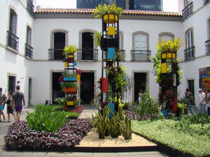
| Casas Casadas - MAP heritage buildings in 1979, is one of the buildings of the nineteenth century's most representative and unique city, a unique example of multi-family residence, similar to the current residential buildings. This building houses since 2004 Riofilme, which plays a key role in revitalizing the national cinema through the production and distribution of Brazilian films, mainly in the domestic market.The equipment has the Cinematheque River, ... |
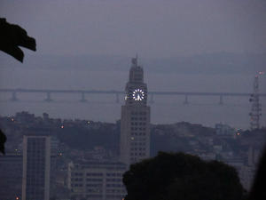 Central do Brasil - MAP The Central Bank of Brazil comprises the region surrounding the train station in Central Brazil in the city of Rio de Janeiro.
The Central Bank of Brazil is located on the edge of the center to the neighborhood of Gamboa, at the Avenida Presidente Vargas, one of the main city of Rio de Janeiro.
In the nineteenth century the Central Bank of Brazil was the station's original railroad Dom Pedro II system, which extended to the states... Central do Brasil - MAP The Central Bank of Brazil comprises the region surrounding the train station in Central Brazil in the city of Rio de Janeiro.
The Central Bank of Brazil is located on the edge of the center to the neighborhood of Gamboa, at the Avenida Presidente Vargas, one of the main city of Rio de Janeiro.
In the nineteenth century the Central Bank of Brazil was the station's original railroad Dom Pedro II system, which extended to the states... |
| Centro Cultural Municipal Oduvaldo Vianna Filho - Castelinho Flamengo - MAP The design of Castelinho Flamengo, tumbled heritage of the city, the Italian architect Gino coped. The property was built in 1918 and was the residence of the wealthy Portuguese entrepreneur and builder responsible for conducting the mansions of society at the time, Joaquim Silva Cardoso. The building was sold to a Portuguese family Fernandes in 1932, when they were performed in the local great and memorable holiday.The cultural center ... |
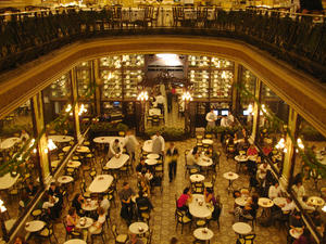 Confeitaria Colombo - MAP A living portrait of Belle Époque in Rio in March and the appreciation of gastronomy in the city, Colombo Confectioners still retains much of its Art Nouveau style of the early century.
His famous Belgian mirrors, windows and their frames in rosewood, Italian marble countertops, chandeliers, floor, and beautiful furnishings remain intact, the same way as they were admired by many famous individuals who not only helped to write the h... Confeitaria Colombo - MAP A living portrait of Belle Époque in Rio in March and the appreciation of gastronomy in the city, Colombo Confectioners still retains much of its Art Nouveau style of the early century.
His famous Belgian mirrors, windows and their frames in rosewood, Italian marble countertops, chandeliers, floor, and beautiful furnishings remain intact, the same way as they were admired by many famous individuals who not only helped to write the h... |
 Convento de Santo Antônio - MAP The Convent of Santo Antonio do Rio de Janeiro is located at Largo da Carioca, on the hill of St. Anthony. The convent way, along with the nearby Church of the Third Order of St. Francis of Penance, one of the oldest and most important remaining colonial assemblies in Rio de Janeiro.http://pt.wikipedia.org/wiki/Convento_de_Santo_Ant%C3%B4nio_(Rio_de_Janeiro) Convento de Santo Antônio - MAP The Convent of Santo Antonio do Rio de Janeiro is located at Largo da Carioca, on the hill of St. Anthony. The convent way, along with the nearby Church of the Third Order of St. Francis of Penance, one of the oldest and most important remaining colonial assemblies in Rio de Janeiro.http://pt.wikipedia.org/wiki/Convento_de_Santo_Ant%C3%B4nio_(Rio_de_Janeiro) |
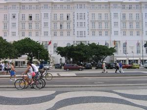 Copacabana Palace - MAP One of the first hotels in the city to be built by the sea, the Copacabana Palace Hotel faithfully reflects the European cultural influence of his time with a sophisticated style of lodging.Opened in 1923, the hotel became a symbol of Rio, as the favorite of artists, politicians, businessmen and international celebrities and grand receptions.Protected by Heritage, the Copacabana Palace has facts on his resume of great importance, for ex... Copacabana Palace - MAP One of the first hotels in the city to be built by the sea, the Copacabana Palace Hotel faithfully reflects the European cultural influence of his time with a sophisticated style of lodging.Opened in 1923, the hotel became a symbol of Rio, as the favorite of artists, politicians, businessmen and international celebrities and grand receptions.Protected by Heritage, the Copacabana Palace has facts on his resume of great importance, for ex... |
| Cultural Center of Park City Ruins - MAP 3 The Cultural Center Hall Ruins Park was created in 1997, works in a home restored by the City of Rio The site belonged to the largest patrons of the arts in the city of Rio de Janeiro, Laurinda Santos Lobo and his uncle Joaquin Murtinho minister government Campos Salles and doctor of the great figures of the Republic. Already in his time at home hosting big soirees, attracting the country's most important artists and international celeb... |
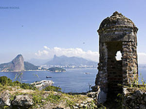
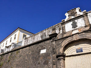 Fortaleza da Conceição - MAP Listed by the National Trust, this fortress built in the eighteenth century deserves a visit for its history and the view that result. Free admission by appointment.It is located in Rio de Janeiro, Morro da Conceicao, since 1711. However, his works began only in 1715 and was completed in 1763. In the following years until 1767, were raised the armory, reserve equipment and workshops. The Viceroy Marquis Lavradio later (1769 - 1779), add... Fortaleza da Conceição - MAP Listed by the National Trust, this fortress built in the eighteenth century deserves a visit for its history and the view that result. Free admission by appointment.It is located in Rio de Janeiro, Morro da Conceicao, since 1711. However, his works began only in 1715 and was completed in 1763. In the following years until 1767, were raised the armory, reserve equipment and workshops. The Viceroy Marquis Lavradio later (1769 - 1779), add... |
 Fortaleza de Santa Cruz in Niteroi - MAP One of the most beautiful fortresses in Brazil.The Fortress of Santa Cruz is the second most visited tourist attraction in Niteroi. With stunning architecture, attracts tourists and researchers in search of leisure and history.With impressive architecture, the fort of Santa Cruz, located in Niterói, it was during periods of colony and empire of Brazil's main defensive structure of Guanabara Bay and the Port of Rio de Janeiro.Garnished ... Fortaleza de Santa Cruz in Niteroi - MAP One of the most beautiful fortresses in Brazil.The Fortress of Santa Cruz is the second most visited tourist attraction in Niteroi. With stunning architecture, attracts tourists and researchers in search of leisure and history.With impressive architecture, the fort of Santa Cruz, located in Niterói, it was during periods of colony and empire of Brazil's main defensive structure of Guanabara Bay and the Port of Rio de Janeiro.Garnished ... |
 Fortaleza São João - MAP São João Fortress / São José Fort
History
The city of Sao Sebastiao do Rio de Janeiro made on 1 March 2005, 440 years old.
The History of the City of Rio de Janeiro, in its infancy, is intertwined with the history of Brazil, embodied and perpetuated through its monuments, forts and buildings restored and preserved.
On March 1, 1565, Estacio de Sá founded in Urca, between the Hills Face Dog and Sugar Loaf, the City of Rio de... Fortaleza São João - MAP São João Fortress / São José Fort
History
The city of Sao Sebastiao do Rio de Janeiro made on 1 March 2005, 440 years old.
The History of the City of Rio de Janeiro, in its infancy, is intertwined with the history of Brazil, embodied and perpetuated through its monuments, forts and buildings restored and preserved.
On March 1, 1565, Estacio de Sá founded in Urca, between the Hills Face Dog and Sugar Loaf, the City of Rio de... |
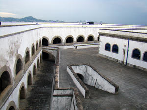
 Forte de Copacabana - MAP The fort that attracts tourists in the country offers, besides the strategic location, diverse entertainment options, with extensive cultural program throughout the year.Occupying a total area of 114,169 m2, the Copacabana Fort was inaugurated in 1914, but then considered the most modern plaza of war in South America in the form of bunker built on 40,000 m2 of e12m thick on their external walls, the strong German Krupp guns had housed i... Forte de Copacabana - MAP The fort that attracts tourists in the country offers, besides the strategic location, diverse entertainment options, with extensive cultural program throughout the year.Occupying a total area of 114,169 m2, the Copacabana Fort was inaugurated in 1914, but then considered the most modern plaza of war in South America in the form of bunker built on 40,000 m2 of e12m thick on their external walls, the strong German Krupp guns had housed i... |
| Forte de Gragoatá in Niteroi - MAP One of the sights of the city of Niteroi, the Fort Gragoatá have their dependencies and walls tumbled by the National Trust. Open to visitors.The Fort or Fortress Gragoatá called in previous times of Fort San Domingo, Gravatá Caraguatá Caracuatá or ended the current name in honor of an abundant plant in the neighborhood of Gravatá.Sua construction predates 1710, when a point of land , Overlooking the beach of São Domingos, Niter�... |
 Forte de São Luiz - MAP Prime location for defense and for touristsThe Fort St. Louis, located in the district Jurujuba in Niteroi, whose main attraction is the stunning view of Guanabara Bay.Its construction dates back to 1567 with the establishment of a surveillance post. The construction of the fort began only in 1770 by order of the Marquis of Lavradio. In 1918 he completed the work initiated by Marshal Hermes da Fonseca, who built a more modern fortress, ... Forte de São Luiz - MAP Prime location for defense and for touristsThe Fort St. Louis, located in the district Jurujuba in Niteroi, whose main attraction is the stunning view of Guanabara Bay.Its construction dates back to 1567 with the establishment of a surveillance post. The construction of the fort began only in 1770 by order of the Marquis of Lavradio. In 1918 he completed the work initiated by Marshal Hermes da Fonseca, who built a more modern fortress, ... |
| Forte do Imbuí in Niteroi - MAP One of the beautiful region of strong Jurujuba in Niteroi, RJBuilt between 1863 and 1901, served as the basis for the biggest guns of the season and currently works as a barracks. It overlooks the open sea.With 2,400 m2 of built area, the Fort Imbuhy started construction in 1863. Function was to connect with other forts in the area, to protect the entrance of Guanabara Bay. In 1877, the work was stopped, and only since 1894, reactivated... |
| Forte do Vigia - MAP Built between 1776 and 1779 by order of the viceroy, Marquis Lavradio, Forte do Vigia fires crossed the Fort Copacabana, and ended his line of defense with a stone gate still today at Ladeira do Leme.The Alferes Joaquim José da Silva Xavier, Tiradentes, served there in 1789 as a member of Company Dragon Mine, who then manned the fort. Renovated by Captain Augusto Tasso Fragoso in 1895, now has the name of Forte do Leme, from 1918, eigh... |
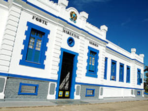 Forte Marechal Hermes in Macaé - MAP Forte Marechal Hermes is located south of the river mouth MacaéBuilt in the late nineteenth century, at the point between the beaches and coves of Imbituba and Shells, Macaé, RJ.It was built in the late nineteenth century by the nascent Republic, on the edge between the beaches and coves of Imbituba and Shells, Macaé, near the site where once stood in the seventeenth century Colonial Fort Santo Antonio de Monte Frio.The original fort... Forte Marechal Hermes in Macaé - MAP Forte Marechal Hermes is located south of the river mouth MacaéBuilt in the late nineteenth century, at the point between the beaches and coves of Imbituba and Shells, Macaé, RJ.It was built in the late nineteenth century by the nascent Republic, on the edge between the beaches and coves of Imbituba and Shells, Macaé, near the site where once stood in the seventeenth century Colonial Fort Santo Antonio de Monte Frio.The original fort... |
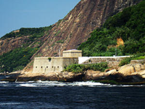
| Forte Tamandaré - MAP (Forte da Lage)Part of the fortifications to defend Guanabara Bay, Fort Tamandaré is one of the oldest buildings and interesting Brazilian army.Strategic location and difficult to maintain.Also called Fort Tamandaré Guanabara. In 1555, he was fortified by Villegaignon that there Ratier installed the battery, with two parts. The weather and the proximity of the sea were factors that contributed to its abandonment by its garrison and pu... |
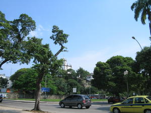
 Guaratiba - Barra de Guaratiba - Pedra de Guaratiba - MAP Guaratiba - Toolbar Guaratiba - Stone GuaratibaGuaratibaRegion initially called "Guratiba-Aitinga" or "Aratuquacima" is an indigenous word used by tupinambás who inhabited our coast during the discovery. Its definition is "a place where there are lots of herons / garceiro." It is easy to see that the word came from two other "wolf", which means "bird" and "tiba" which means "place where there is much gathered. "Then:" Guaratiba. This d... Guaratiba - Barra de Guaratiba - Pedra de Guaratiba - MAP Guaratiba - Toolbar Guaratiba - Stone GuaratibaGuaratibaRegion initially called "Guratiba-Aitinga" or "Aratuquacima" is an indigenous word used by tupinambás who inhabited our coast during the discovery. Its definition is "a place where there are lots of herons / garceiro." It is easy to see that the word came from two other "wolf", which means "bird" and "tiba" which means "place where there is much gathered. "Then:" Guaratiba. This d... |
 Igreja da Candelária - MAP The church of Our Lady of Candelaria is located in the city center of Rio de Janeiro. It is one of the main religious monuments in the city.
The parochial chapel of Candelaria in 1710 but was reformed in the second half of the eighteenth century, needed to expand. Sergeant-Major John Francis Roscio, Portuguese military engineer, designed the plans for a new church. Construction began in 1775 and the inauguration, with the still unfin... Igreja da Candelária - MAP The church of Our Lady of Candelaria is located in the city center of Rio de Janeiro. It is one of the main religious monuments in the city.
The parochial chapel of Candelaria in 1710 but was reformed in the second half of the eighteenth century, needed to expand. Sergeant-Major John Francis Roscio, Portuguese military engineer, designed the plans for a new church. Construction began in 1775 and the inauguration, with the still unfin... |
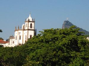
 Igreja Nossa Senhora da Gloria do Outeiro - MAP The Outeiro da Glória, formerly called "Morro do Leripe" or "Uruçumirim", he presented sudden sea and was the site, described by Mem de Sa, where was the "fortress of biroaçumirim with many French and ... artillery. "Conquered by the Portuguese on 20 January 1567, under the command of the founder of the city of Sao Sebastiao do Rio de Janeiro, Estacio de Sa, is the most important place in the historiography of Rio. First, because the... Igreja Nossa Senhora da Gloria do Outeiro - MAP The Outeiro da Glória, formerly called "Morro do Leripe" or "Uruçumirim", he presented sudden sea and was the site, described by Mem de Sa, where was the "fortress of biroaçumirim with many French and ... artillery. "Conquered by the Portuguese on 20 January 1567, under the command of the founder of the city of Sao Sebastiao do Rio de Janeiro, Estacio de Sa, is the most important place in the historiography of Rio. First, because the... |
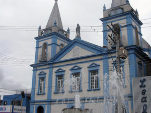
 Igreja Nossa Senhora da Penha - MAP It stands out for popular devotion, widespread in almost every country, and the original location, on a cliff high enough and pure rock, causing it to be seen from miles away.
It was built in 1635, as simple and rustic chapel, by Captain Baltazar de Abreu Cardoso, on land they own. In 1728, the brotherhood was transformed into Venerable Brotherhood of Our Lady of Penha de France.
Works were made for the expansion, especially the s... Igreja Nossa Senhora da Penha - MAP It stands out for popular devotion, widespread in almost every country, and the original location, on a cliff high enough and pure rock, causing it to be seen from miles away.
It was built in 1635, as simple and rustic chapel, by Captain Baltazar de Abreu Cardoso, on land they own. In 1728, the brotherhood was transformed into Venerable Brotherhood of Our Lady of Penha de France.
Works were made for the expansion, especially the s... |
 Igreja Nossa Senhora de Bonsucesso - MAP Built into the complex of Santa Casa de Misericordia, the church of Our Lady of Bonsucesso is one of the oldest churches in the city.Just to give you an idea, building the first chapel was started in 1567, close to Castle Hill. Rebuilt in 1780, guard the altar and pulpit remnants of the Jesuit church, demolished the Castle Hill.Address: Rua Santa Luzia , 206 - Centro Igreja Nossa Senhora de Bonsucesso - MAP Built into the complex of Santa Casa de Misericordia, the church of Our Lady of Bonsucesso is one of the oldest churches in the city.Just to give you an idea, building the first chapel was started in 1567, close to Castle Hill. Rebuilt in 1780, guard the altar and pulpit remnants of the Jesuit church, demolished the Castle Hill.Address: Rua Santa Luzia , 206 - Centro |
 Ilha Fiscal - MAP The island was first called "Ilha Fiscal Rat. The name referred to the large number of mice that had been fleeing from snakes from Snake Island. There, in another version, a few gray stones scattered about the island that resembled rats at bay.
Castle Island was designed by engineer Joseph Del Vecchio Adoph to the Ministry of Finance that there was intended to have a customs post. Del Vecchio, who was director of the ministry of wor... Ilha Fiscal - MAP The island was first called "Ilha Fiscal Rat. The name referred to the large number of mice that had been fleeing from snakes from Snake Island. There, in another version, a few gray stones scattered about the island that resembled rats at bay.
Castle Island was designed by engineer Joseph Del Vecchio Adoph to the Ministry of Finance that there was intended to have a customs post. Del Vecchio, who was director of the ministry of wor... |
| Memorial Municipal Getúlio Vargas - MAP The Memorial Hall is a tribute Getulio Vargas of City Hall at one of the largest Brazilian politicians, ex-President Getulio Vargas. Created in 2004, 50 years after his death, the equipment is located at Praça Luís de Camões, site of civic events that included the presence of a statesman. The monument is under the protection of historical heritage city, state and federal.In addition to portraying the history of Getulio Vargas, to com... |
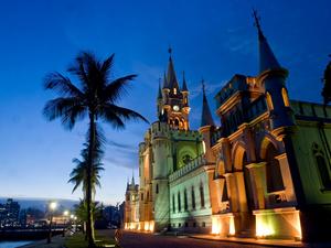
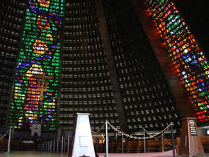 Metropolitan Cathedral - MAP Located in the financial heart of the city of Rio de Janeiro, the cathedral is part of the cultural map.
The architectural design, which draws attention due to its shape, is the architect Edgar de Oliveira da Fonseca. The cathedral, cone-shaped (pyramid), is 106 meters in diameter at the base and 96 feet high. The main door is decorated with 48 bronze bas-reliefs on the theme of Faith.
Inside, the stained glass in vivid colors, ex... Metropolitan Cathedral - MAP Located in the financial heart of the city of Rio de Janeiro, the cathedral is part of the cultural map.
The architectural design, which draws attention due to its shape, is the architect Edgar de Oliveira da Fonseca. The cathedral, cone-shaped (pyramid), is 106 meters in diameter at the base and 96 feet high. The main door is decorated with 48 bronze bas-reliefs on the theme of Faith.
Inside, the stained glass in vivid colors, ex... |
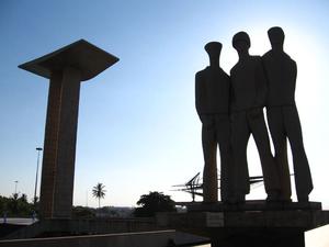 Monumento dos Pracinhas - MAP The Monument to the dead of World War II, popularly known as Pracinhas Monument, located in the park Eduardo Gomes, the city of Rio de Janeiro, Brazil.
The monument was designed by architects Mark Netto Konder and Helio Ribas Marinho, winners of a national competition, having opened in 1960 [1].
It houses the remains and pay homage to the Brazilian military that had been deposited in the cemetery in Pistoia, Italy, at the time of ... Monumento dos Pracinhas - MAP The Monument to the dead of World War II, popularly known as Pracinhas Monument, located in the park Eduardo Gomes, the city of Rio de Janeiro, Brazil.
The monument was designed by architects Mark Netto Konder and Helio Ribas Marinho, winners of a national competition, having opened in 1960 [1].
It houses the remains and pay homage to the Brazilian military that had been deposited in the cemetery in Pistoia, Italy, at the time of ... |
 Mosteiro de São Bento - MAP Monastery of St. BenedictGood conditions for the protection offered by the site at the top of the hill overlooking the Bay of Guanbara, besides the great weather - thanks to the wholesome winds of the bay, away from wetlands, represented strong motivations for the Benedictine monks and John Frei Pedro Ferraz Porcalho accepted in 1590, giving this wide strip of land, a nobleman Manuel de Brito, who there had built a chapel to Our Lady of... Mosteiro de São Bento - MAP Monastery of St. BenedictGood conditions for the protection offered by the site at the top of the hill overlooking the Bay of Guanbara, besides the great weather - thanks to the wholesome winds of the bay, away from wetlands, represented strong motivations for the Benedictine monks and John Frei Pedro Ferraz Porcalho accepted in 1590, giving this wide strip of land, a nobleman Manuel de Brito, who there had built a chapel to Our Lady of... |
 National Library Foundation - BNF - MAP The National Library is the institution that preserves the bibliographic and documentary heritage of Brazil. With a wealth currently estimated at 9 million items, is considered by UNESCO as the eighth largest national library in the world and the largest in Latin America. Its headquarters are in Rio de Janeiro, Avenida Rio Branco. Beyond it, the National Library Foundation - BNF also encompasses the Library Euclides da Cunha - BEC, loca... National Library Foundation - BNF - MAP The National Library is the institution that preserves the bibliographic and documentary heritage of Brazil. With a wealth currently estimated at 9 million items, is considered by UNESCO as the eighth largest national library in the world and the largest in Latin America. Its headquarters are in Rio de Janeiro, Avenida Rio Branco. Beyond it, the National Library Foundation - BNF also encompasses the Library Euclides da Cunha - BEC, loca... |
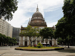
 Paço Imperial - MAP The Imperial Palace is a multicultural area with intense and diverse programming of visual arts, cinema, theater, music, library, educational activities, seminars, service shops and restaurants.Stage of key events in the history of Brazil, focuses the Palace and a reference load values noted, both the historical point of view and as a work of architecture and art.The Imperial Palace has a rich multicultural area with diverse progr... Paço Imperial - MAP The Imperial Palace is a multicultural area with intense and diverse programming of visual arts, cinema, theater, music, library, educational activities, seminars, service shops and restaurants.Stage of key events in the history of Brazil, focuses the Palace and a reference load values noted, both the historical point of view and as a work of architecture and art.The Imperial Palace has a rich multicultural area with diverse progr... |
| Palácio Gustavo Capanema - MAP Capanema The Palace is one of first examples of modern architecture in Brazil.
Its construction occurred from 1937 to 1945. The project inspired by Le Corbuisier, was led by Lucio Costa and had a young team comprised of architects Oscar Niemeyer, Carlos Leão, Jorge Moreira, Ernani Affonso Eduardo Reidy and Vasconcellos.
It is known as the building of MEC since served as headquarters of the Ministry of Education and Culture. In movi... |
 Paraty - MAP 6
The Historic City of Paraty is one of the most enchanting scenery of the State of Rio. Listed as a National Historic Landmark, the small town from the south coast has been declared World Heritage by UNESCO. The site emerged in the XVIIIth century, as the main port to drain the gold brought from Minas Gerais State.
Squeezed between the sea and mountains, the former "Town of Our Lady of Remedies Paraty" is certainly one of ... Paraty - MAP 6
The Historic City of Paraty is one of the most enchanting scenery of the State of Rio. Listed as a National Historic Landmark, the small town from the south coast has been declared World Heritage by UNESCO. The site emerged in the XVIIIth century, as the main port to drain the gold brought from Minas Gerais State.
Squeezed between the sea and mountains, the former "Town of Our Lady of Remedies Paraty" is certainly one of ... |
 Petrópolis - MAP 6
Located 68 km from Rio, Petrópolis was discovered in 1830 by Emperor D. Peter I. Delighted with the climate and the beauty of the place, the imperial family bought a farm there. Thirteen years later, King Pedro II gave rise to the city, built to host the Court. Even today Petrópolis keeps the charm of those glory days, with the aristocratic mansions of the barons, earls and viscounts, located near the Imperia... Petrópolis - MAP 6
Located 68 km from Rio, Petrópolis was discovered in 1830 by Emperor D. Peter I. Delighted with the climate and the beauty of the place, the imperial family bought a farm there. Thirteen years later, King Pedro II gave rise to the city, built to host the Court. Even today Petrópolis keeps the charm of those glory days, with the aristocratic mansions of the barons, earls and viscounts, located near the Imperia... |
 Praça XV de Novembro - MAP Praça XV de Novembro, no doubt can be considered one of the most important city of Rio de Janeiro, because it occurred over several centuries, the most significant events that affected the fate not only the city but also the country.At the commencement of the seventeenth century when the Castle Hill began to be small for the city, it launched itself to the Meadow, where there was already a chapel, built to Our Lady of O ', located in a... Praça XV de Novembro - MAP Praça XV de Novembro, no doubt can be considered one of the most important city of Rio de Janeiro, because it occurred over several centuries, the most significant events that affected the fate not only the city but also the country.At the commencement of the seventeenth century when the Castle Hill began to be small for the city, it launched itself to the Meadow, where there was already a chapel, built to Our Lady of O ', located in a... |