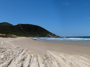
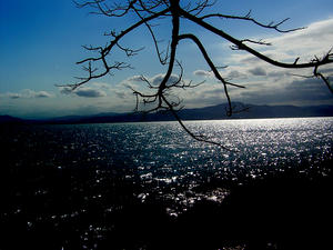
 Açores Beach - MAP 7
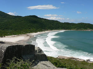
The water at the 2´km long beach is blue, considered cold and has medium waves, with good ecological trails amid the Atlantic Forest. From Açores Beach you can see the Três Irmãs Island and Moleques do Sul Beach. Being surrounded by hills it allows several interesting trails.
Açores Beach is located roughly 30 km from the city center o... Açores Beach - MAP 7
The water at the 2´km long beach is blue, considered cold and has medium waves, with good ecological trails amid the Atlantic Forest. From Açores Beach you can see the Três Irmãs Island and Moleques do Sul Beach. Being surrounded by hills it allows several interesting trails.
Açores Beach is located roughly 30 km from the city center o... |
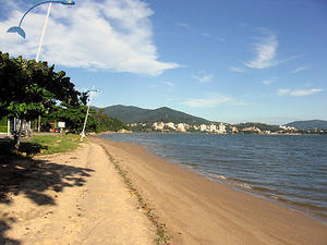
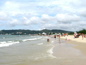
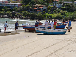
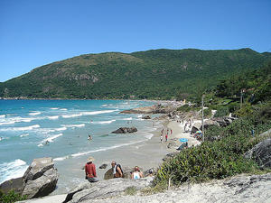
 Armação Beach - MAP 4
The 3.20 km Armação Beach, also called Armação do Pântano do Sul, is pretty quiet ... in the "centrinho" at one end there is trade, the houses, the village of fishermen, their boats, the restaurants on the beach ... as you walk to the other end, the beach becomes deserted, and then they come up with surfers. The beach is very tasty and worth a visit!
Located 25 km... Armação Beach - MAP 4
The 3.20 km Armação Beach, also called Armação do Pântano do Sul, is pretty quiet ... in the "centrinho" at one end there is trade, the houses, the village of fishermen, their boats, the restaurants on the beach ... as you walk to the other end, the beach becomes deserted, and then they come up with surfers. The beach is very tasty and worth a visit!
Located 25 km... |
 Armação do Pântano do Sul Beach - MAP 4
The 3.20 km Armação do Pântano do Sul Beach is pretty quiet ... in the "centrinho" at one end there is trade, the houses, the village of fishermen, their boats, the restaurants on the beach ... as you walk to the other end, the beach becomes deserted, and then they come up with surfers. Despite a good amount of waves, is good for swimming. The beach is very tasty and worth a visit! It receives touri... Armação do Pântano do Sul Beach - MAP 4
The 3.20 km Armação do Pântano do Sul Beach is pretty quiet ... in the "centrinho" at one end there is trade, the houses, the village of fishermen, their boats, the restaurants on the beach ... as you walk to the other end, the beach becomes deserted, and then they come up with surfers. Despite a good amount of waves, is good for swimming. The beach is very tasty and worth a visit! It receives touri... |
 Balneário Beach - MAP 5
Located on the northern mainland of Florianópolis, the beach is roughly 1 mile long and formely known as " Barreiros´ " and now known by several names, including Praia do Balneário, Praia do Estreito or even Praia do Balneário do Estreito. The beach offers a wide view to the right of Avenida Beira-Mar Norte, of small islands in the North Bay and the Hercílio Luz Bridge&nbs... Balneário Beach - MAP 5
Located on the northern mainland of Florianópolis, the beach is roughly 1 mile long and formely known as " Barreiros´ " and now known by several names, including Praia do Balneário, Praia do Estreito or even Praia do Balneário do Estreito. The beach offers a wide view to the right of Avenida Beira-Mar Norte, of small islands in the North Bay and the Hercílio Luz Bridge&nbs... |
 Barra da Lagoa - MAP 4
The beach is the largest fishing nucleus of Florianópolis and one of the most sought after by tourists for its very clean and calm waters and a few waves. Amid its natural beauties there is a river that comes from the Lagoa da Conceição and ends up meeting with the sea of Barra. It's all very harmonious nature and fishing village.
Surrounded by azorean villages and buildings, the suspension bridge that co... Barra da Lagoa - MAP 4
The beach is the largest fishing nucleus of Florianópolis and one of the most sought after by tourists for its very clean and calm waters and a few waves. Amid its natural beauties there is a river that comes from the Lagoa da Conceição and ends up meeting with the sea of Barra. It's all very harmonious nature and fishing village.
Surrounded by azorean villages and buildings, the suspension bridge that co... |
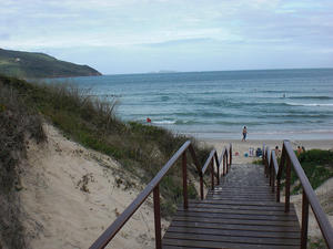
 Bom Abrigo Beach - MAP 4
Bom Abrigo is considered a good neighborhood in the Brazilian city of Florianopolis, capital of Santa Catarina. It is located in the continental part of the city to the south, between the districts of Itaguaçu and Abraham and South Bay. It is known for a stunning sunset. Praia do Bom Abrigo belongs to the District Headquarters and is distant 5 km from the city center. It has 300 meters long and its width... Bom Abrigo Beach - MAP 4
Bom Abrigo is considered a good neighborhood in the Brazilian city of Florianopolis, capital of Santa Catarina. It is located in the continental part of the city to the south, between the districts of Itaguaçu and Abraham and South Bay. It is known for a stunning sunset. Praia do Bom Abrigo belongs to the District Headquarters and is distant 5 km from the city center. It has 300 meters long and its width... |
 Brava Beach - MAP 4
With crystal clear waters, natural beauty and great waves for surfing and bodyboarding Brava is one of the most beautiful beaches in the vicinities of Florianópolis. It lies on the Santa Catarina Island far north coast, 38 kilometers from the center of Florianópolis. Northwest from the beach, following the coast, lies the Ingleses beach.
It has about 1.900 m long, and is inserted between two rocky headlan... Brava Beach - MAP 4
With crystal clear waters, natural beauty and great waves for surfing and bodyboarding Brava is one of the most beautiful beaches in the vicinities of Florianópolis. It lies on the Santa Catarina Island far north coast, 38 kilometers from the center of Florianópolis. Northwest from the beach, following the coast, lies the Ingleses beach.
It has about 1.900 m long, and is inserted between two rocky headlan... |
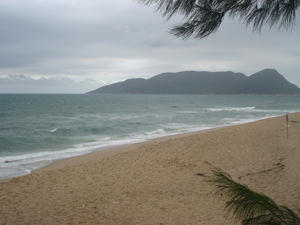
 Cachoeira do Bom Jesus Beach - MAP 4
The district of Cachoeira do Bom Jesus is 30 km from downtown Florianópolis. Its name derives from the waterfall (Cachoeira) located on Bom Jesus Hill. The beach is named after the district it is located in. It lies beside the Canasvieiras beach, with the same beautiful natural characteristics such as fine white sand, calm, clean and warm waters but it's quieter than its neighbor. Connected to Canasvieiras and P... Cachoeira do Bom Jesus Beach - MAP 4
The district of Cachoeira do Bom Jesus is 30 km from downtown Florianópolis. Its name derives from the waterfall (Cachoeira) located on Bom Jesus Hill. The beach is named after the district it is located in. It lies beside the Canasvieiras beach, with the same beautiful natural characteristics such as fine white sand, calm, clean and warm waters but it's quieter than its neighbor. Connected to Canasvieiras and P... |
 Cacupé Beach - MAP 4
The beach is found in the neighborhood of Cacupé 12 km from Florianopolis. Cacupé consists of two points that are encroaching on the Baiá Norte of Santa Catarina Island, called Cacupé Grande and Cacupé Pequeno. These are also the names given to two sandy beaches of the locality, each beach located next to its tip. It is composed of very shaded small thick yellow sandy beaches with calm sea. Good pla... Cacupé Beach - MAP 4
The beach is found in the neighborhood of Cacupé 12 km from Florianopolis. Cacupé consists of two points that are encroaching on the Baiá Norte of Santa Catarina Island, called Cacupé Grande and Cacupé Pequeno. These are also the names given to two sandy beaches of the locality, each beach located next to its tip. It is composed of very shaded small thick yellow sandy beaches with calm sea. Good pla... |
 Campeche Beach - MAP 4
Located on the east coast, Praia do Campeche is 15 lm from downtown and 10 km from International Airport Hercilio Luz is a beautiful beach with 5 km long white sand, crystal clear water in a heavy sea of emerald hues. Because of its location and the beauty of the place Campeche beach has had a considerable grown in the last 4 years. Fine homes and buildings have been built, making it one of most appreciated beaches of Florianó... Campeche Beach - MAP 4
Located on the east coast, Praia do Campeche is 15 lm from downtown and 10 km from International Airport Hercilio Luz is a beautiful beach with 5 km long white sand, crystal clear water in a heavy sea of emerald hues. Because of its location and the beauty of the place Campeche beach has had a considerable grown in the last 4 years. Fine homes and buildings have been built, making it one of most appreciated beaches of Florianó... |
 Canajurê Beach - MAP 4 Canajure is a small beach with about 100 meters long located on the northern island of Santa Catarina, between the Canasvieiras and Jurerê beaches. It is a beach that is independent, a little bit of a CANASvieiras and JURErê, hence its name. It has its beginning at the Ponta do Morretes and follows a southwesterly direction to a point of rocks (unnamed) that starts the Jurerê Beach.
With crystal clear waters, gentle waves and ... Canajurê Beach - MAP 4 Canajure is a small beach with about 100 meters long located on the northern island of Santa Catarina, between the Canasvieiras and Jurerê beaches. It is a beach that is independent, a little bit of a CANASvieiras and JURErê, hence its name. It has its beginning at the Ponta do Morretes and follows a southwesterly direction to a point of rocks (unnamed) that starts the Jurerê Beach.
With crystal clear waters, gentle waves and ... |
 Canasvieiras Beach - MAP 4
When the Azoreans founded the settlement of São Francisco de Paula das Cana Vieiras in 1754, they probably never imagined it would become one of the busiest places in Florianópolis.
Natural beauty, complete facilities and bilingual customer service at most establishments makes Canasvieiras one most Latin American´s tourists favorite resort in Florianópolis. It is also the most popular destin... Canasvieiras Beach - MAP 4
When the Azoreans founded the settlement of São Francisco de Paula das Cana Vieiras in 1754, they probably never imagined it would become one of the busiest places in Florianópolis.
Natural beauty, complete facilities and bilingual customer service at most establishments makes Canasvieiras one most Latin American´s tourists favorite resort in Florianópolis. It is also the most popular destin... |
 Coqueiros Beach - MAP 4
Coqueiros (coconuts) neighborhood is located in the continental part of the city to the south. It is the place for those who like to snack and have a pleasant scenery as accompaniment. The place is busy, served by many bars and restaurants and decorated by some palm trees that are left after the human occupation of the site. Proximity to urban center has deteriorated increasingly both the sea and the sand, now grounded by ... Coqueiros Beach - MAP 4
Coqueiros (coconuts) neighborhood is located in the continental part of the city to the south. It is the place for those who like to snack and have a pleasant scenery as accompaniment. The place is busy, served by many bars and restaurants and decorated by some palm trees that are left after the human occupation of the site. Proximity to urban center has deteriorated increasingly both the sea and the sand, now grounded by ... |
 Daniela Beach - MAP 4
The 3 km long Daniela beach lies in a bay of calm waters with no waves, fine sand with very nice temperature. Acess is easy, through its wide streets, where locals and vacationers pass. The site is very popular for families with small children. Not many service options. Bathed by the warm waters of the North Bay and a strip of sand that works almost like a huge playground, is great for those who go to the beach with ch... Daniela Beach - MAP 4
The 3 km long Daniela beach lies in a bay of calm waters with no waves, fine sand with very nice temperature. Acess is easy, through its wide streets, where locals and vacationers pass. The site is very popular for families with small children. Not many service options. Bathed by the warm waters of the North Bay and a strip of sand that works almost like a huge playground, is great for those who go to the beach with ch... |
 Forte Beach - MAP 4
Located 25 km from the center of Florianópolis, the beach of Ponta Grossa, also known as Praia do Forte is only 90 meters long, is a sea of clear water and gentle waves and a very white, fine and soft sand beach. It is possible to penetrate into the sea by walking up to 220 meters. The beach retains the characteristics of calm waters, which resemble a large green swimming pool.
Previously, the site was exc... Forte Beach - MAP 4
Located 25 km from the center of Florianópolis, the beach of Ponta Grossa, also known as Praia do Forte is only 90 meters long, is a sea of clear water and gentle waves and a very white, fine and soft sand beach. It is possible to penetrate into the sea by walking up to 220 meters. The beach retains the characteristics of calm waters, which resemble a large green swimming pool.
Previously, the site was exc... |
 Gravatá Beach - MAP 4
Gravatá beach is located on the eastern Santa Catarina Island side, between the beach of Joaquina and Mole beaches, in Florianópolis.
Totally wild, the Gravatá inhospitable shore is one of the most virgin and beautiful of the city. The Praia do Gravatá is quite small, but at the end of it there is a little hill from where you can see a breathtaking scenery, the rough sea and waves break... Gravatá Beach - MAP 4
Gravatá beach is located on the eastern Santa Catarina Island side, between the beach of Joaquina and Mole beaches, in Florianópolis.
Totally wild, the Gravatá inhospitable shore is one of the most virgin and beautiful of the city. The Praia do Gravatá is quite small, but at the end of it there is a little hill from where you can see a breathtaking scenery, the rough sea and waves break... |
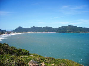
 Guarda do Embaú Beach - MAP 4
Guarda do Embaú is a beach located in Palhoça, SC, Brazil, 46 km south of Florianópolis and 755 km from São Paulo. Access is made by crossing the Madre River. Its level varies and the cross is often made with water at the neck, sometimes the water is lower. But there's no need to worry, since there are many fishermen who help along the way for R$ 2 (round trip).
The beach is considered... Guarda do Embaú Beach - MAP 4
Guarda do Embaú is a beach located in Palhoça, SC, Brazil, 46 km south of Florianópolis and 755 km from São Paulo. Access is made by crossing the Madre River. Its level varies and the cross is often made with water at the neck, sometimes the water is lower. But there's no need to worry, since there are many fishermen who help along the way for R$ 2 (round trip).
The beach is considered... |
 Ingleses Beach - MAP 4
Ingleses is a gorgeous beach with 5 km long, open ocean, blue waters, with few waves that appeal to swimmers of all ages. It has tourist infrastructure of excellent quality combining exuberant nature, comfort and fun for tourists in any season.
In summer the Ingleses beach, is the second resort at concentration of foreign tourists, second only to Canasvieiras. In winter, mullet fishing, religious celebrations and folkl... Ingleses Beach - MAP 4
Ingleses is a gorgeous beach with 5 km long, open ocean, blue waters, with few waves that appeal to swimmers of all ages. It has tourist infrastructure of excellent quality combining exuberant nature, comfort and fun for tourists in any season.
In summer the Ingleses beach, is the second resort at concentration of foreign tourists, second only to Canasvieiras. In winter, mullet fishing, religious celebrations and folkl... |
 Itaguaçu Beach - MAP 4
Itaguaçu beach is located between the Morro João Dias (Forte beach) and the Balneario de Ubatuba, 15 km from the Historical Center.
One of the most beautiful beaches in South San Francisco neighborhood, it has gained visibility in recent years, becoming very honored by vacationers in the region. It has wide strip of sand and sea water clear and lively, and somewhat dangerous, with st... Itaguaçu Beach - MAP 4
Itaguaçu beach is located between the Morro João Dias (Forte beach) and the Balneario de Ubatuba, 15 km from the Historical Center.
One of the most beautiful beaches in South San Francisco neighborhood, it has gained visibility in recent years, becoming very honored by vacationers in the region. It has wide strip of sand and sea water clear and lively, and somewhat dangerous, with st... |
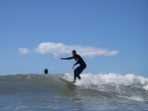
 Joaquina Beach - MAP Joaquina is an ocean beach in the Brazilian city of Florianopolis, east of Santa Catarina Island, south of Brazil. The point sought by surfers, has been home to some world championship of surfing.
The name of the beach is new, first seen in maps from 1975. Until then, she was called Campeche beach. Praia da Joaquina belongs to the District of Lagoa da Conceição and is only 15 km from downtown Florianopolis in the nor... Joaquina Beach - MAP Joaquina is an ocean beach in the Brazilian city of Florianopolis, east of Santa Catarina Island, south of Brazil. The point sought by surfers, has been home to some world championship of surfing.
The name of the beach is new, first seen in maps from 1975. Until then, she was called Campeche beach. Praia da Joaquina belongs to the District of Lagoa da Conceição and is only 15 km from downtown Florianopolis in the nor... |
 Jurerê Beach - MAP 4
In the neighborhood of Jurerê, northern of Santa Catarina island lies the Jurerê beach. With its famous emerald green warm waters, long and calm waves, this fine and clear sandy beach is between Canasvieiras and Forte beaches.
This beach, the most traditional of the island of Santa Catarina, for its strategic position, together with the tip of land to the west, had the first name of Ponta Grossa, in ref... Jurerê Beach - MAP 4
In the neighborhood of Jurerê, northern of Santa Catarina island lies the Jurerê beach. With its famous emerald green warm waters, long and calm waves, this fine and clear sandy beach is between Canasvieiras and Forte beaches.
This beach, the most traditional of the island of Santa Catarina, for its strategic position, together with the tip of land to the west, had the first name of Ponta Grossa, in ref... |
 Lagoa da Conceição - MAP
Situated in the geographical center of the island of Santa Catarina, Lagoa da Conceição neighborhood gathers beaches, dunes, mountains and the largest lagoon of the island. With such diversity, the place became the best known natural landmark in Florianopolis.
Besides tourists, athletes of various sports also take advantage of this diversity. In the pond is common to find windsurfers, sailing, kayaking, kite surfing... Lagoa da Conceição - MAP
Situated in the geographical center of the island of Santa Catarina, Lagoa da Conceição neighborhood gathers beaches, dunes, mountains and the largest lagoon of the island. With such diversity, the place became the best known natural landmark in Florianopolis.
Besides tourists, athletes of various sports also take advantage of this diversity. In the pond is common to find windsurfers, sailing, kayaking, kite surfing... |
 Lagoinha Beach - MAP
Lagoinha is a beach and a neighborhood in the city of Florianopolis. It lies at the northern end of Santa Catarina Island, between two rocky points, Ponta das Canas to the west, and Praia Brava to the east. The neighborhood and beach belong to the district of Cachoeira do Bom Jesus.
This area gets fewer swimmers than the beaches on either side, due to accessibility. The two beaches on either side of Lag... Lagoinha Beach - MAP
Lagoinha is a beach and a neighborhood in the city of Florianopolis. It lies at the northern end of Santa Catarina Island, between two rocky points, Ponta das Canas to the west, and Praia Brava to the east. The neighborhood and beach belong to the district of Cachoeira do Bom Jesus.
This area gets fewer swimmers than the beaches on either side, due to accessibility. The two beaches on either side of Lag... |
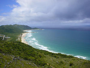
 Lagoinha do Leste Beach - MAP
The Lagoinha do Leste beach is in the city of Florianópolis, and it is located in the southeast end of the island.
The beach was hard to get to, and due to access issues it has ended up preserving a great example of last strongholds of the Atlantic Forest in Florianopolis. The beach contains about 600 acres of land and contains an S shaped lagoon.
The beach is accessed via the Matadeiro bea... Lagoinha do Leste Beach - MAP
The Lagoinha do Leste beach is in the city of Florianópolis, and it is located in the southeast end of the island.
The beach was hard to get to, and due to access issues it has ended up preserving a great example of last strongholds of the Atlantic Forest in Florianopolis. The beach contains about 600 acres of land and contains an S shaped lagoon.
The beach is accessed via the Matadeiro bea... |
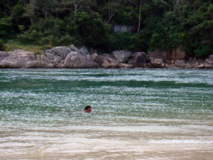
 Matadeiro Beach -
Located on the southern island of Florianopolis and facing the Atlantic Ocean, Matadeiro beach is separated from the beach of Armação by a stream of fresh water. The water here has medium waves attracting surfers who wish to practice or train. The end of the beach has one of the tracks to Lagoinha do Leste beach.
The beach is relatively quite and only accessible by foot. Inaccessible for cars, the beach stil... Matadeiro Beach -
Located on the southern island of Florianopolis and facing the Atlantic Ocean, Matadeiro beach is separated from the beach of Armação by a stream of fresh water. The water here has medium waves attracting surfers who wish to practice or train. The end of the beach has one of the tracks to Lagoinha do Leste beach.
The beach is relatively quite and only accessible by foot. Inaccessible for cars, the beach stil... |
| Meio Beach - MAP 3
The beach is located in Florianópolis, and is among one of the many beaches surrounding the city. Meio (middle) Beach has calm sea and thick sand.
It lies 3 km from the center of Florianópolis, is located in a residential neighborhood, between the beaches and Itaguaçu da Saudade, so got its name.
With almost 400 meters long, despite having many attractions around and have an excellent infrastructu... |
 Moçambique Beach - MAP 6
The Moçambique Beach, also known as Praia Grande is located in the northeast of the island of Santa Catarina, in Forest Park of the Red River, 29 kilometers from the center. It is famous for being the largest of the island, which stretches about 13 kilometers long.
The beach has clear and cold water and good waves for surfing. The sand is medium thick and fluffy. There are very few buildings on the beach and the... Moçambique Beach - MAP 6
The Moçambique Beach, also known as Praia Grande is located in the northeast of the island of Santa Catarina, in Forest Park of the Red River, 29 kilometers from the center. It is famous for being the largest of the island, which stretches about 13 kilometers long.
The beach has clear and cold water and good waves for surfing. The sand is medium thick and fluffy. There are very few buildings on the beach and the... |
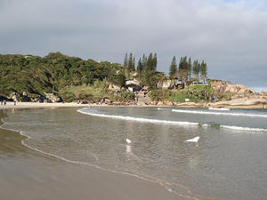
 Mole Beach - MAP 4
Praia Mole lies on the east coast of Santa Catarina Island. It has clear waters, with big and strong waves, loose and soft sand. The Mole Beach is well maintained it has footvoley courts, mini-ramp, paddle with good tourist infrastructure, kiosks, parking, showers, restrooms, lifeguards and a few hotels and inns.
Facing the Atlantic Ocean Mole beach is one of the most sought after by surfers. Despite having best equipp... Mole Beach - MAP 4
Praia Mole lies on the east coast of Santa Catarina Island. It has clear waters, with big and strong waves, loose and soft sand. The Mole Beach is well maintained it has footvoley courts, mini-ramp, paddle with good tourist infrastructure, kiosks, parking, showers, restrooms, lifeguards and a few hotels and inns.
Facing the Atlantic Ocean Mole beach is one of the most sought after by surfers. Despite having best equipp... |
 Morro das Pedras Beach - MAP 5
Morro das Pedras is both the name of a neighborhood in Florianópolis as well as this beach in the south of the islands. They were named after the hill between Campeche and Armação beaches. In "Morrão" (big hill) as it is called by locals, the strong south wind does not change the conditions of its waves, and a beautiful spectacle of nature can be appreciated when the sea crashes ag... Morro das Pedras Beach - MAP 5
Morro das Pedras is both the name of a neighborhood in Florianópolis as well as this beach in the south of the islands. They were named after the hill between Campeche and Armação beaches. In "Morrão" (big hill) as it is called by locals, the strong south wind does not change the conditions of its waves, and a beautiful spectacle of nature can be appreciated when the sea crashes ag... |
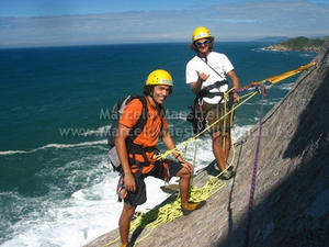
 Naufragados Beach - MAP
Praia dos Naufragados is located 43 km from the city center of Florianópolis, in southern Santa Catarina. A trail roughly 1 mile long separates the beach road from where there are waterfalls and ruins of a flour mill.
On the beach there is the Lighthouse and the remains of three cannons that served to protect the bay from invaders.
It would be hard to imagine all this belligerence on a beach so quiet, starting with the... Naufragados Beach - MAP
Praia dos Naufragados is located 43 km from the city center of Florianópolis, in southern Santa Catarina. A trail roughly 1 mile long separates the beach road from where there are waterfalls and ruins of a flour mill.
On the beach there is the Lighthouse and the remains of three cannons that served to protect the bay from invaders.
It would be hard to imagine all this belligerence on a beach so quiet, starting with the... |
| Palmeiras Beach - MAP This beach is located in Floronopolis and is one of many beaches available. We are currently looking for more information on the beach.
|
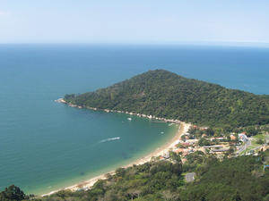
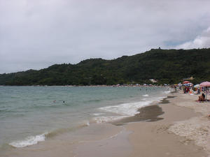
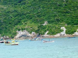
 Pântano do Sul Beach - MAP
Considered one of the richest colonies of fishermen of the island, the beach of Pântano do Sul has an area of 2,35 km long, with relatively busy open sea.
Located 31 km from the center of Florianópolis, the majority of its patrons are locals and tourists seeking a more peaceful place to live. Costa Norte is one of those places. Besides having around 200 houses and a crystal clear sea, there are always lifeguard... Pântano do Sul Beach - MAP
Considered one of the richest colonies of fishermen of the island, the beach of Pântano do Sul has an area of 2,35 km long, with relatively busy open sea.
Located 31 km from the center of Florianópolis, the majority of its patrons are locals and tourists seeking a more peaceful place to live. Costa Norte is one of those places. Besides having around 200 houses and a crystal clear sea, there are always lifeguard... |
| Ponta Beach - MAP This beach is found in Florianopolis, which has an enormous number of beaches, most of which are unique and full of tourists year round. The waters around Florianopolis are often used for surfing, and surfing competitions. |
 Ponta das Canas Beach - MAP
This beach shares the same name as the neighborhood it is found in. Ponta das Canas is in Florianopolis, the capital of Santa Catarina, Brazil and is located on northern Santa Catarina Island.
The beach is roughly 1km long, with calm waters and is considered a popular tourist destination. Historically it was a fishing village, but tourism has started to take over the beach, making it a nice location to... Ponta das Canas Beach - MAP
This beach shares the same name as the neighborhood it is found in. Ponta das Canas is in Florianopolis, the capital of Santa Catarina, Brazil and is located on northern Santa Catarina Island.
The beach is roughly 1km long, with calm waters and is considered a popular tourist destination. Historically it was a fishing village, but tourism has started to take over the beach, making it a nice location to... |
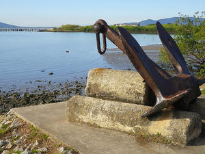
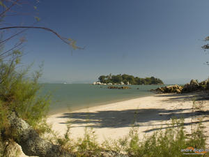
 Praia da Barra do Sambaqui - MAP
Barra do Sambaqui is a small beach located in the North Bay in Florianópolis, Santa Catarina. It is beautiful are that divides Ratones Mangrove and Sambaqui Beach.
The Beach Bar Shellmound is the last beach of Ponta do Sambaqui. It is about 360m in length, but lacks well-defined geographic boundaries, as are two stones, one north and one south, which delimit the beginning and end, respectively. It is a sm... Praia da Barra do Sambaqui - MAP
Barra do Sambaqui is a small beach located in the North Bay in Florianópolis, Santa Catarina. It is beautiful are that divides Ratones Mangrove and Sambaqui Beach.
The Beach Bar Shellmound is the last beach of Ponta do Sambaqui. It is about 360m in length, but lacks well-defined geographic boundaries, as are two stones, one north and one south, which delimit the beginning and end, respectively. It is a sm... |
| Praia da Galheta - MAP The Galheta beachis a wild beach located east of the island of Santa Catarina, which is situated Florianopolis, capital of the Brazilian state of Santa Catarina. It is accessible only by trails, low degree of difficulty, starting at Praia Mole or the channel of Barra da Lagoa, 15 km from the Capital Centre. Naturism is allowed by municipal law since 1997, but was practiced for many years.The Association of Friends of Galheta also develo... |
 Praia da Galheta - MAP Although it is located between two of the busiest beaches of Ilha de Santa Catarina - Mole and Barra da Lagoa, beach Galheta and semi-desert, with access by a trail of 300 meters from the coast north of Mole.
Completely blank, with no infrastructure of bars and restaurants Cruet is ideal for those who enjoy nature in all its extension. Small strands of freshwater showers provide refreshing and revitalizing, the crystalline waters and... Praia da Galheta - MAP Although it is located between two of the busiest beaches of Ilha de Santa Catarina - Mole and Barra da Lagoa, beach Galheta and semi-desert, with access by a trail of 300 meters from the coast north of Mole.
Completely blank, with no infrastructure of bars and restaurants Cruet is ideal for those who enjoy nature in all its extension. Small strands of freshwater showers provide refreshing and revitalizing, the crystalline waters and... |
 Ribeirão da Ilha Beach - MAP
Beach Ribeirão da Ilha is located in the south bay of Florianopolis, capital of Santa Catarina, and consists of several smaller beaches.
Located 36 kilometers from the center of Florianopolis, Ribeirão da Ilha is composed of several small beaches, calm waters and sand. It is considered one of the few places in the southern coast of Brazil that conserves the traces of Portuguese colonization. A walk to the... Ribeirão da Ilha Beach - MAP
Beach Ribeirão da Ilha is located in the south bay of Florianopolis, capital of Santa Catarina, and consists of several smaller beaches.
Located 36 kilometers from the center of Florianopolis, Ribeirão da Ilha is composed of several small beaches, calm waters and sand. It is considered one of the few places in the southern coast of Brazil that conserves the traces of Portuguese colonization. A walk to the... |
 Sambaqui Beach - MAP
Sambaqui is both a beach and neighborhood in Florianopolis, in the district of Santo Antonio de Lisboa. The beach, roughly 17 km from the city center of Florianópolis, has calm waters, as is the channel of the island with the mainland. Azorean-style homes line the shore which offers a beautiful view of downtown Florianopolis.
Roughly 1 km long, the beach derives its name from the existence of heaps of shells scat... Sambaqui Beach - MAP
Sambaqui is both a beach and neighborhood in Florianopolis, in the district of Santo Antonio de Lisboa. The beach, roughly 17 km from the city center of Florianópolis, has calm waters, as is the channel of the island with the mainland. Azorean-style homes line the shore which offers a beautiful view of downtown Florianopolis.
Roughly 1 km long, the beach derives its name from the existence of heaps of shells scat... |
 Santinho Beach - MAP
Santinho beach is situated in the Ingleses do Rio Vermelho district at a 40 km distance from downtown. It offers a tranquil retreat for visitors and residents. With its two miles long, of open water and agitated, provides good conditions for sea sports such as surfing. On the north of Praia do Santinho, after the coast, is Praia dos Ingleses, and to the south is the Moçambique beach.
Bordering the beach, the cliffs ar... Santinho Beach - MAP
Santinho beach is situated in the Ingleses do Rio Vermelho district at a 40 km distance from downtown. It offers a tranquil retreat for visitors and residents. With its two miles long, of open water and agitated, provides good conditions for sea sports such as surfing. On the north of Praia do Santinho, after the coast, is Praia dos Ingleses, and to the south is the Moçambique beach.
Bordering the beach, the cliffs ar... |
 Santo Antônio de Lisboa - MAP
The beach is found within the district of Santo Antônio de Lisboa, and part of the general area of Florianopolis, the capital of the Brazilian state of Santa Catarina. The Santo Antonio de Lisboa beach, 750 meters long and 2-40 meters wide, is an internal and small beach with calm sea and yellowish sand, with some grayed stretches due to the outflow of small streams. It begins in the North, in the Quilombo creek and ends at the... Santo Antônio de Lisboa - MAP
The beach is found within the district of Santo Antônio de Lisboa, and part of the general area of Florianopolis, the capital of the Brazilian state of Santa Catarina. The Santo Antonio de Lisboa beach, 750 meters long and 2-40 meters wide, is an internal and small beach with calm sea and yellowish sand, with some grayed stretches due to the outflow of small streams. It begins in the North, in the Quilombo creek and ends at the... |
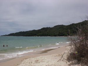
 Saquinho Beach - MAP
The Saquinho Beach is a small beach of white sand, clear waters and rough seas. It is located at the southern face of the island of Florianópolis, Santa Catarina. Access to the beach is through a trail from the Solidão Beach. Walking the trail takes roughly 20 minutes. Saquinho Beach - MAP
The Saquinho Beach is a small beach of white sand, clear waters and rough seas. It is located at the southern face of the island of Florianópolis, Santa Catarina. Access to the beach is through a trail from the Solidão Beach. Walking the trail takes roughly 20 minutes.
|
 Solidão Beach - MAP 5
Formerly called Rio das Pacas beach, the Solidão Beach is a small cove between Costa de Dentro and Saquinho.
The beach is considered one of the most beautiful landscapes of Santa Catarina to be a paradise almost untouched. The beautiful scenery presents a vision of white sand and clear waters surrounded by green hills of the Atlantic Forest. Among the trees at the end of the strip of sand, it is poss... Solidão Beach - MAP 5
Formerly called Rio das Pacas beach, the Solidão Beach is a small cove between Costa de Dentro and Saquinho.
The beach is considered one of the most beautiful landscapes of Santa Catarina to be a paradise almost untouched. The beautiful scenery presents a vision of white sand and clear waters surrounded by green hills of the Atlantic Forest. Among the trees at the end of the strip of sand, it is poss... |
 Tapera Beach - MAP
This beach is a traditional fishing colony, south of the island. On weekends it changes completely, upon receiving the population that resides in the center of Florianopolis. Currently there are already permanent residents from the city center.
The Tapera beach is calm, like a pond. From its margin it is possible to see the Fora Beach and Sonho beach, resorts on the continent and belonging to the municipality of Palho&ccedi... Tapera Beach - MAP
This beach is a traditional fishing colony, south of the island. On weekends it changes completely, upon receiving the population that resides in the center of Florianopolis. Currently there are already permanent residents from the city center.
The Tapera beach is calm, like a pond. From its margin it is possible to see the Fora Beach and Sonho beach, resorts on the continent and belonging to the municipality of Palho&ccedi... |