| Aeroclube Plaza Show Geral - MAP 3
The Flying Club Plaza Show opened in 1999 with a concept of outdoor shopping mall. It has restaurants, cafes, shops, services, pharmacies, travel agency, banks, opticians, jewelry stores and nightclubs, and cinema. After a crisis, and many shops closed, received an investment of $ 50 million in 2007 to be transformed into the Aero Club Shopping & Office.
The new proposal is a Lifestyle Center. The space has the com... |
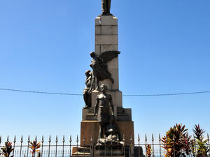 Castro Alves Square - MAP Tribute to Bahia Castro Alves, and one of the biggest stages of the Carnival of Salvador. A sculpture of the poet, in bronze and granite and signed by the Italian Pasquale Di Chirico, is one of the highlights of the square.The meeting the "electric trios" of the city during the carnival.Rua Chile, s / n, Pelourinhohttp://www.360cities.net/image/praca-castroalves-salvador-bahia-brazil#318.30,-20.10,70.0 Castro Alves Square - MAP Tribute to Bahia Castro Alves, and one of the biggest stages of the Carnival of Salvador. A sculpture of the poet, in bronze and granite and signed by the Italian Pasquale Di Chirico, is one of the highlights of the square.The meeting the "electric trios" of the city during the carnival.Rua Chile, s / n, Pelourinhohttp://www.360cities.net/image/praca-castroalves-salvador-bahia-brazil#318.30,-20.10,70.0 |
 Chapada Diamantina - MAP 7
At the heart of the Brazilian state of Bahia, are the Chapada Diamantina, a region of mountains, where many rivers are born, including the Paraguaçu Jacuípe and Contas Rivers. These small streams of water from natural springs slide down these mountains forming beautiful streams that tumbe over waterfalls and form bubbling transparent pools, only to continue on through the state to the ocean.
The nat... Chapada Diamantina - MAP 7
At the heart of the Brazilian state of Bahia, are the Chapada Diamantina, a region of mountains, where many rivers are born, including the Paraguaçu Jacuípe and Contas Rivers. These small streams of water from natural springs slide down these mountains forming beautiful streams that tumbe over waterfalls and form bubbling transparent pools, only to continue on through the state to the ocean.
The nat... |
| Consórcio Parques Urbanos - MAP Av Otávio Mangabeira 6000, 41706690 Salvador
71 34610392 |
 Costa Azul Park - MAP Costa Azul Park It occupies an area of approximately 55 thousand square meters and is located in the neighborhood of the same name. It has a football field, exercise equipment, two playgrounds with bike racks, bike paths, jogging trails and boardwalks at different levels, four restaurants, with choices of international foods, typical, pasta or meat, outdoor amphitheater with capacity for 600 people, light source, with 150 parking... Costa Azul Park - MAP Costa Azul Park It occupies an area of approximately 55 thousand square meters and is located in the neighborhood of the same name. It has a football field, exercise equipment, two playgrounds with bike racks, bike paths, jogging trails and boardwalks at different levels, four restaurants, with choices of international foods, typical, pasta or meat, outdoor amphitheater with capacity for 600 people, light source, with 150 parking... |
| Dique do Tororó Metropolitan Park - MAP 3 The construction of the dam was a Dutch who lived in Salvador from 1624. Been abandoned for decades, but was re-urbanized in 1998. The Dique de Tororo is the only natural source of Salvador overturned by the Institute of National Historical and Artistic Heritage, which has a pond of 110 cubic meters of water.Beyond the pond, the site has a jogging track, lanes for rowing, fishing decks, piers for small boats, sports and fitness equipmen... |
| Iso Parque Recreativo - MAP Rua Panorama 26, 41502065 Salvador
71 32521358 |
 Metropolitan Park Pituaçu - MAP 7
This is the largest green area for public use in Salvador. Those who visit this park will certainly never regret it. Included in the park is the Pituaçu lagoon, which resembles a very large clover, taking up nearly 200,000 square meters of space. A pier was installed at the lagoon where visitors can rent paddle boats, which gives a view of this magnificent park. An eighteen kilome... Metropolitan Park Pituaçu - MAP 7
This is the largest green area for public use in Salvador. Those who visit this park will certainly never regret it. Included in the park is the Pituaçu lagoon, which resembles a very large clover, taking up nearly 200,000 square meters of space. A pier was installed at the lagoon where visitors can rent paddle boats, which gives a view of this magnificent park. An eighteen kilome... |
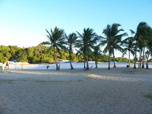 Metropolitano do Abaeté Park - MAP Situated within an Environmental Protection Area (APA), with about 12 thousand square meters, has the most famous lagoon of murky water of the city - Lagoa do Abaeté - white sand dunes and an extremely rich vegetation. In the urbanized, has the Central Core, where are located the Hub, the House of Washerwomen and House of Music from Bahia, and more than two miles of taxiways, kiosks for selling coconut water, acarajé sugarcane juice a... Metropolitano do Abaeté Park - MAP Situated within an Environmental Protection Area (APA), with about 12 thousand square meters, has the most famous lagoon of murky water of the city - Lagoa do Abaeté - white sand dunes and an extremely rich vegetation. In the urbanized, has the Central Core, where are located the Hub, the House of Washerwomen and House of Music from Bahia, and more than two miles of taxiways, kiosks for selling coconut water, acarajé sugarcane juice a... |
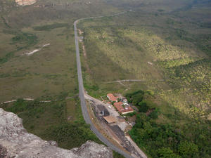
 Parque Nacional das Nascentes do Rio Parnaíba - 7
Created through a decree on July 16, 2002, Parque Nacional das Nascentes do Rio Parnaíba is located on the border between the states of Piaui, Maranhao, Bahia and Tocantins. It aims to ensure the preservation of natural resources and biological diversity as well as provide the scientific research and development, activities for educational purposes, recreational activities and ecotourism.
The park has an area of... Parque Nacional das Nascentes do Rio Parnaíba - 7
Created through a decree on July 16, 2002, Parque Nacional das Nascentes do Rio Parnaíba is located on the border between the states of Piaui, Maranhao, Bahia and Tocantins. It aims to ensure the preservation of natural resources and biological diversity as well as provide the scientific research and development, activities for educational purposes, recreational activities and ecotourism.
The park has an area of... |
| Parque Nacional do Descobrimento - National Park Discovery is a Brazilian national parks and composes with the National Park of Monte Pascoal and Pau Brazil an ecological corridor of the Atlantic Forest Reserves Discovery Coast.It was established on April 20, 1999, near the celebrations of 500 years of Brazil in an attempt to preserve remnants of Atlantic forest of southern Bahia and has no infrastructure to be open to visitors.It is administered by the Chico Mendes Inst... |
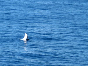 Parque Nacional Marinho dos Abrolhos - 7
This national marine park, is located in the souther coast of Bahia, in the Abrolhos Bank. Parque Nacional Marinho dos Abrolhos was the first park in Brazil to receive the recognition and title of National Marine Park, through a governmental decree on April 6, 1983.
It is administered by the Chico Mendes Institute for Biodiversity Conservation (ICMBio). Parque Nacional Marinho dos Abrolhos - 7
This national marine park, is located in the souther coast of Bahia, in the Abrolhos Bank. Parque Nacional Marinho dos Abrolhos was the first park in Brazil to receive the recognition and title of National Marine Park, through a governmental decree on April 6, 1983.
It is administered by the Chico Mendes Institute for Biodiversity Conservation (ICMBio).
|
| St. Bartholomew Park - MAP 7
In 1929, the State Government acquired by a friendly expropriation, the land needed for use as a watershed and to protect the associated lands. The was needed to solve water problems within the city, and thus was an important piece of land for everyone. However, it is surrounded by mining industries, and agricultural industries which has made the battle to protect it intense.
Over the past... |